| << | 40 | 41 | 42 | #43, Sweden | 44 | 45 | 46 | 47 | 48 | #49, South Africa, Mozambique, and Swaziland Bicycle Tour | >> |

Be sure to hover the mouse over the images.

Bicycle Tour Adventure #40

Day 1, 2, 3,
Side Visits: Pinos Altos, Gila Cliff Dwellings,
Petroglyph National Monument

Pictures and Stories About Bicycle Tour Adventures

Great Divide Mountain Bike Route (GDMBR - Segment):
Tyrone, Tyrone Copper Mine, Silver City, Pinos Altos,
Lake Roberts, to Gila National Forest, (Southern Section),
New Mexico; By Bicycle Tour; February (Valentine's Week), 2012


Day 2 - Continental Divide (crossing #28) to Lake Roberts
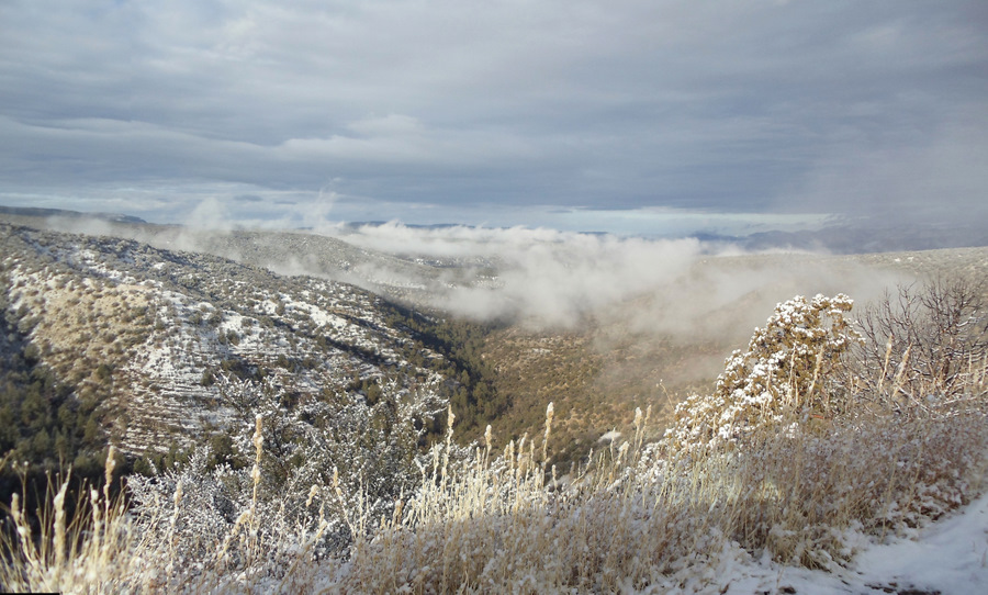
New Mexico portion of the Mogollon Rim.
Overview: It snowed 2 to 6 inches during the night. We decided to visit the Gila Cliff Dwellings (where there was no snow) this morning, in hopes that the snow would melt in the NM Hwy-35 mountain valley. The snow did melt by the time that we returned from the Cliff Dwellings, but it was obviously going to snow that evening. We had about a two hour biking window, so we rode the segment from the Continental Divide (crossing #28) to Lake Roberts (skipping the mountain forest segment for this day because of snow on the road). The Cliff Dwellings, Lake Roberts and this day's Bike Route are all inside Gila National Forest.

Above: 2012, Valentine's Day, morning: Looking over the New Mexico portion of the Mogollon Rim (pronounced Mugy-on, also the name of ancient natives who settled this area, way before Mimbres). See the Gila Cliff Dwellings page.

I'm ready to go! Flag painted by Dennis on September 12, 2001.
Above: 'I'm ready to go!' It is getting ready to snow and it will be snowing in 2 hours. For the first time ever, we are riding downhill; we just don't have the time to ride uphill in this weather window.

BTW, that abstract flag on the side of the trailer panel was freehand painted by Dennis on September 12th, 2001 - It was therapy.

Terry and the Bee at Continental Divide crossing #28. Welcome - Trail of the Mountain Spirits - Scenic Byway.
Above Left: Terry and the Bee at Continental Divide crossing #28 of the Great Divide Mountain Bike Route (GDMBR). Believe it or not, the bicycle is a hard tail mountain bike, the front shocks are hidden behind the panniers.

Above Right: Welcome - Trail of the Mountain Spirits - Scenic Byway.
We are cycling westward on NM Hwy-35 on the spirit trail (in and out of Gila National Forest and private ranch property). We will be visited by a Bald Eagle and see Hoodoo spirit formations, all within a few miles. It will turn out to be an awesome ride!

The road ahead. Tall Pines - This should be called Pine Alley.
Above Left: The road ahead. The portion of the map that we are on is over the handlebar bag's curvature.

Above Right: Tall Pines - This should be called Pine Alley. It was a very pleasant ride through an old forest.

Terry and the Bee. The white stone looking items are sleet balls. Our first, of many, Hoodoos.
Above Left: Terry and the Bee. The red bag is a motorcycle helmet; now you know how I get back to the transport vehicle and trailer. If I were smarter, I would have remembered to leave the helmet with the motorcycle (ahem).

The white stone looking items are sleet balls (not hail).

Above Right: Our first, of many, Hoodoos. 'Hoodoo' is an actual Geology term meaning tall narrow rock formation (often with human spiritual meaning).

More sleet. I see a sphinx and a snoopy.
Above Left: More sleet.

Above Right: I see a sphinx and a snoopy.

Hoodoos on the GDMBR. Terry hugs a spirit.
Above Left: Hoodoos.

Above Right: Terry hugs a spirit.

Cool rock stratification and hoodoos. Cool rock stratification and hoodoos.
Above: Cool rock stratification and hoodoos.

Cool rock stratification. Hello Eagle, Thank You for making our day!
Above Left: Cool rock stratification.

Above Right: Hello Eagle, Thank You for making our day!

Bald Eagle. Bald Eagle.
Above: The same Bald Eagle.

Lake Roberts (today's destination), 3 Miles. Beautiful mountain stratification in the Spirit Valley.
Above Left: Lake Roberts (the Village, is today's destination), 3 Miles.

Above Right: Beautiful mountain stratification in the Spirit Valley.

We see Lake Roberts. Climb, climb, climb!
Above Left: We see Lake Roberts, finally. We need to climb over a hill to get to our Rental Cabin. We will later discover that the top of the hill has some old Mimbres Native American Ruins (from the 1100s).

Above Right: Climb, climb, climb!

Cedar varient, perhaps very old. Cedar varient, perhaps very old.
Above: This tree appears to be a Cedar variant, perhaps very old; the tree bark has become blocked, like alligator armor. This is our first observation but we will see about five more trees like this over a three day period.
Addendum: A friend, formerly from this area, Doug Pape, told us that this tree (Juniperus Deppeana) is commonly called Alligator Juniper or Checkerbark Juniper.
My faithful companion. A view from toward the south.
Above Left: My faithful companion (reaching to hold the handlebar steady while Dennis takes Cedar Bark pictures).

Above Right: A view from toward the south and a part of Lake Roberts is captured.

More climbing. Ruins of Mimbres Dwellings.
Above Left: More climbing.

Above Right: Ruins of Mimbres Dwellings. We did stop and look.

Mimbres dwelling styles over time. Mimbres dwelling deppression in the ground.
Mimbres dwelling deppression in the ground. Mimbres dwelling deppression in the ground.

How to Recognize an Ancient Mimbres Ground Dwelling

Above: Mimbres (pronounced Mim-braez) dwellings were, typically, half in the ground and half out with wood framed roofs with covers of animal hide, bark, and/or dirt (very much like Viking/Celtic digs). This Mimbres construction method means that an undisturbed ground dwelling, over time, just looks like a round or square depression in the ground, usually about 15 feet (5 meters) in diameter. The dwellings do not have rock borders, so it takes a bit of experience to see these ancient homes for what they were.

It is noteworthy that the Mimbres Culture only lasted about a hundred years and that they dispersed mainly into the Hopi and Pueblo Nations (and their respective oral histories talk of this merging). It is interesting that, maybe, the conceptual knowledge or some of the knowledge of Kiva making and Pueblo building evolved from the Mimbres.

Looking westward over the town of Lake Roberts. Deer at Lake Roberts.
Above Left: Standing at the west end of the Mimbres Dwelling site, looking westward over the town of Lake Roberts (most of the town is hidden by the vegetation at the bottom of the picture frame).

Above Right: Deer, located between the Volunteer Fire Department Building and the Lake Roberts General Store.

The Lake Roberts General Store (and Cabins). Our Cabin Bedroom.
Above Left: The Lake Roberts General Store (and Cabins).

Above Right: Our Cabin Bedroom.

Living Area. Kitchen.
Above Left: Living Area.

Above Right: Kitchen.

Kitchen View (half hour after check-in). Bike View (1 hour after check-in).
Above Left: Kitchen View - Flurries (half hour after check-in).

Above Right: Bike View (1 hour after check-in).


This ends the travel log/travelogue for Day 2.
See our Gila Cliff Dwelling tour pictures.


Previous Day Top Next Day