| << | 40 | 41 | 42 | #43, Sweden | 44 | 45 | 46 | 47 | 48 | #49, South Africa, Mozambique, and Swaziland Bicycle Tour | >> |

| 1 | Bike Tour: 2345678 | Auto/Ferry/Train/Bus: 9101112 | Stockholm: 1314151617 |
Sweden, Bicycle Tour Adventure #43, Day 3

Pictures and Stories About Bicycle Tour Adventures


Day 3
Bicycle from the Wreta Gestgifveri near Jönåker
to the Brunn Hotel in Söderköping, Sweden
The Weather is Cool and Mostly Sunny

Wonder Woman and Superman.

Above: Wonder Woman and Superman (arh arh).

We're clean and packed, Breakfast time. awesome old multi-level Parlor Stove.

Lighting is not very favorable.

Above Left: Up and 'at em'. We're clean and packed, Breakfast time. It is a 'DIY' Continental Breakfast and a 'Make and Pack your own Lunch' event. Yay Muslix and Yogurt!

Above Right: This is an awesome old multi-level Parlor Stove, it will keep food and beverages warm and it has a lot of surface area to warm a cold room.

Our cottage loft. Gloving up.

Above Left: Our cottage loft.

Above Right: Gloving up.

we're going left/eastward here. Long shadows greet us this early cool morning.

Above Left: Back to the main road, we're going left/eastward here but southwestward for the day. In other words, we will be riding into the Sun all day long.

Above Right: Long shadows greet us this early cool morning.

we're heading toward Nyköping. This road leads to a ski lift.

Navigation: We will be facing the Sun for most of the day as it traverses the sky from east to west (left to right).
The Sun is warm on the face and body but it makes for poor pictures.

Above Left: For the moment we're heading toward Nyköping but today we are heading for Söderköping

    Nor ~ North, Söd ~ South, Ny ~ ?

    We think that 'köping', pronounced 'shirping', means Shop, Shops, or Shopping and it may be distantly related to the English word for Shipping - Terry, my Latin speaking, linguistic, wife, figured this out.

    See the little Yellow Näckrosleden Sign?

Above Right: Well, we are in a low altitude, high latitude, snowy winter environment. This road leads to a ski lift - Lots of 'up' for a little while.

    We actually pedaled our bikes up this slope, the angle is as steep as we could handle in the configuration of these rental bikes; further note that if this were the end of the day we would probably be pushing these bikes.

Pedaling on the high road. Wonder Woman and Superman.

Above: Pedaling on the high road.

Alpine Lupine. Dennis and Terry Struck on Sweden Bike Tour.

Above Left: Alpine Lupine (also Lupis and Lupin - Identification help/yelp from Diaz Alejandro, Jean V, and Dale Beeman).

Above Right: Us - Heather in the background.

Algebra (for the dyslexic). Mail Boxes.

Above Left: Algebra (for the dyslexic) - The region is also called Ålberga.

Above Right: Mail Boxes: Water Proof, Rust Proof, and Snow Proof. In Engineering, we call this a great re-use of another intended product (called the covered plastic trash can).

There is no doubt that we are in Snow and Rain country.

Sweden reminds me of both Western Washington State and the Alaskan Rainlands. There are some parallels between Alaska and Sweden as they are both located at the same Latitudes and they are both in the northwest corners of their respective continents. Alaska and Sweden are breeding grounds for hundreds of migrating fowl and animals, both above the land and in the water.

Train overpass. Crops ready to harvest.

Above Left: Train overpass.

Above Right: Crops ready to harvest.

Farmer did a quick repair. Hanging Elektrisk Lantern.

Above Left: Farmer did a quick repair.

Above Right: Hanging Elektrisk Lantern.

Roadside Timber Pile/Stack. Horses at the (electric) gate.

Above Left: Roadside Timber Pile/Stack. These stockpiles were pretty common in Sweden.

The Swedes have a much more active timber harvest and fire prevention program than in the US. Most of the road sides (where 90% of fires start) are also thinned out. Frankly, I was impressed by their forestry management. I'm stating this after having watched the largest Colorado Forest Fire in recorded history, what a waste of good timber (yes, I understand the value of forest fires and grass fires said the Eagle Scout).

Above Right: Horses at the (electric) gate; this usually means that it is feeding time by the owner/farmer caretaker. Notice the more modern/newer Electric Ribbon along the top of the fence.

Roadway. Hunting Blind.

Above Left: Roadway.

Above Right: Hunting Blind - We would bike through a few forest sections that had a Blind about every 1/2 kilometer (or 1/4 mile).

Lumber Mill/Yard. Resistance is Futile.

Above Left: Lumber Mill/Yard. We're turning for the Sun.

Above Right: Resistance is Futile. From Ken Leitch: "We are the Borg. You will be assimilated." I think that Borg is a variation of 'Berg' or 'Burg', of course there is Bjorn too (he is from Sweden).

NOT Mail Boxes. Large Farm operation.

Above Left: NOT Mail Boxes.

Above Right: Large Farm operation, There are no small farms in Sweden, they have all suffered the same economic issues as USA Farms, get bigger or get out of business.

two hundred year old road/distance markers. two hundred year old road/distance markers.

Milsten (Milestone) or Milstenar (Milestones):

These are First of a few two hundred year old distance/mileage markers. The marker on the right states "3/4 MIL"; it is 3/4 of the way to the next [full distance] MIL Marker (MIL is pronounced Mile).
See Milsten2, Milsten3, or Milsten4 for other Milestone examples.

About Sweden's Milsten (Milestone) Markers

Milsten (Milestone) Marker Distances:
  • 1649-1891 Distance: In 1649 the Swedish Crown had introduced strictly defined and standardized distances, distance markers and marker methods, and strict or controlled measuring methods. In 1649 the old Swedish Mil distance (pronounced Mile) was 18000 Alnar (which is about 10,688 meters or 6.21 UK/US Miles).
  • 1891-1942 Distance: In the year 1891 (in effect 1895) the Mil distance became 10.68 Kilometers and the marker became known as "Milstolpe" (Mile Stop) and was called a "10 km Post". It is 6.63 UK/US Miles.
Original Roman Miliaria (Milage) History:
  • A milestone is roadside marker and it is a precursor to modern road signs.
  • The Milestone predecessor was called Miliaria (Latin) which were stone cylinders that were erected along the Roman Empire's main roads and the markers indicated the distance to Rome or the nearest governing seat.
  • The Romans were first to use the unit of long distance Mille Passuum (literally "a thousand paces" in Latin). Each Roman Pace or Stride was two steps) - It denoted a distance of 1,000 paces and it is estimated to be about 1,479 meters, 1,617 yards, or 0.919 UK/US miles).
  • A Roman Mile was not too far off from the current English Mile (and England probably evolved their Mile from the Roman Mil as a result of Roman Occupation from around 25 BC to about 300 AD).
Swedish Historical Issues:
  1. Inaccurate distances were given for travel by the Hostelry Industry for travel distance (some closer than indicated, some further than indicated, and each having advantages or disadvantages for time, effort, energy, and costs spent in travel).
  2. Government reimbursement for Traveling Agents of the was problematic, sometimes incurring outright fraud.
  3. The actual measure of a distance was not standardized (each person's pace is different).
  4. Some places had different distance measures than other areas, but maybe used the same word (Mil for instance).
  5. Accurate distance measuring became important to actual government jurisdiction and the government taxation process.
General Swedish History:
  • Sweden used milestones to mark distances on roads, at first on main roads (highways) then on secondary roads (country roads).
  • The Swedish method incorporated the concepts of ancient Roman Marker styles as well as Danish methods from the 1500's.
  • All of these systems used a Major Sized Distance Marker and Interim Distance Markers.
  • Milstenar (Milestones) marked 1/4, 1/2, and 3/4 distances (of a Mil).
  • The initial Milestones were made of wood and later stones were added to be longer lasting and to be more tamperproof.
  • Mileage markers became distances to and from royal palaces and were important both for administrative reimbursement but also related to the taxation process.
  • It has been and still is against the law to disturb Milemarkers, now it is more a case of Antiquities disturbance than for Taxation or Reimbursement issues.
Major route change and gathering of 3 different bicycle tour routes. We're near the summit, it is not a big pass.

Above Left: Major route change and gathering of 3 different bicycle tour routes. We are gathering up to go through the only pass for about a 50 M / 80 k radius.

Above Right: We're near the summit, it is not a big pass by any means, and we may be at a 400'/120m elevation from 40'/12m. We are in a Heather, Birch, and Pine woodland. Still, long morning shadows.

Heather and Birch. Another old roadway marker.

Above Left: Heather and Birch.

Above Right: Another Milestone Marker, 1/2 MIL. See Milsten (Milestone) for a detailed explanation.

We're heading for Öst Husby. A promotional Viking Boat.

Above Left: We're heading for Öst Husby by way of the Ferry [shown as the boat icon].

Ö is an abbreviation for Öst or Öster, which means East (Latin based, even the country of Austria/ Österreich/Oesterreich means Eastern Land/Territory).

Above Right: A promotion, this is as close as we will be seeing a Viking Boat.

In about a week, we will see the Vasa in Stockholm and it is promoted as a Viking Ship but it is a three masted double rowed canon war ship from the 1700s.

The only existing "fully intact" Viking Ship is in Oslo, Norway.

west side of Kvarsebo. west side of Kvarsebo.

Above: Entering the west side of Kvarsebo.

A Grade School (West Side of Kvarsebo).

Above: A Grade School (West Side of Kvarsebo).

Milk Cans, Old Distance Marker, and Bus Stop. if a person misses the turn, one will end up in the drink.

Above Left: There are a few different things going on here:

  1. It is fashionable in Sweden (and the American Midwest) for former farms, farmers, former farmers, and for people who grew up on farms to display old Milk Containers.
  2. Notice the Old Distance Marker. I was not smart enough to get a picture of the face. See Milsten (Milestone) for a detailed explanation.
  3. At the bus stop the sign indicates the town of Kvarsebo KA but the KA (I came to figure) means in the 'area of' or 'vicinity of' the official town (outside the official town limit). At some point I realized that the KA designation was probably also related to taxes.
  4. Gee, just two dwelling colors, Barn Red and Crème Brûlé.

Above Right: View of Bråviken Bay, if a person misses the turn, one will end up in the drink. Bråviken Bay reminds us, a little bit, of the Firth of Forth. We are facing south but will hit the coast, turn right/west, parallel Bråviken Bay for a few kilometers and then catch the FREE Ferry across the bay (biking around would take 2 additional days).

Composite view of Bråviken Bay.

Above: Composite view of Bråviken Bay.

Safe harbor. Safe harbor.
Views along Bråviken Bay. Views along Bråviken Bay.

Above: Views along Bråviken Bay.

Sod Roof. Upper Party Deck.

Above Left: We're looking at the Sod Roof.

Above Right: Note the Upper Party Deck!

Bråviken Bay. Island in Bråviken Bay.
We just missed the Ferry. we will have to wait 30 minutes.

Above: We just missed the Ferry; we will have to wait 30 minutes, that's not too bad a wait time (other places are 4 hours). Oh yeah, the Water Closet is 1 kilometer that way.

Front row seating. Front row seating.

Above: Front row seating.

The other side. Fire Hydrant ahead.

Above Left: The other side.

Above Right: Fire Hydrant ahead (actually its a minor road crossing/intersection).

Major Birch Bark Split. Flat Lands, more or less, for two days.

Above Left: Major Birch Bark Split (this is common with Birch).

Above Right: We're going to be on Flat Lands, more or less, for two days.

major heavy duty plastic wrap. Flat Land and Major Intersection ahead.

Above Left: There is plenty of moisture in Sweden; Farmers need to pack-up grass when it is dry and then protect it from wet weather, ergo major heavy duty plastic wrap. Farmers also have a machine that grabs these one ton rolls and moves them for repositioning or transporting.

Above Right: Flat Land and Major Intersection ahead (we're still heading toward the Big Ö).

Ö Husby, Sweden. Ö Husby, Sweden.

Above: Ö Husby, Fotboll (Soccer Match), and we bike through town past a church converted to a Muslim Mosque (no picture, first Non-Christian faith seen by us in Sweden).

stopping on a little side road for lunch. Fireweed.

Above Left: We're stopping on a little side road for lunch.

Above Right: Fireweed.

We're entering Kuddby. most of the original Christian Churches were built on the sacred grounds.

Above Left: We're entering Kuddby.

Above Right: We see a Church. We're not into Churches (Kyrka, Kyrkan) per se but something drew us to this church. Historically most of the original Christian Churches were built on the sacred grounds, chapel sites, or alters of other previous religions. I noticed that this church was built on a mound. It would not take long for us to find an ancient Celtic alter - It was hidden from those who would not see it .

Propably a Celtic Burial Marker. This marker has 3rd generation Celtic Runes.

Above Left: First, we walked through all of the older grave markers/stones with Latin/Swedish text, some up to 200 hundred year old. We already knew for what to look. When we saw this marker, we knew that we were on the right track.

Above Right: Then, we found this marker, closest to the mound that I thought, from a distance, may be a Druid or Celtic site. This marker has 3rd generation Celtic Runes (an ancient language, called Viking Runes after Christianization). Note that in many places Christianization was violent.

Celtic Alter Site. plenty of Barn Red Dwellings.

Above Left: Finally, I knew that we had arrived at the Celtic Alter Site, this is it. The big stepping stone is original; the little stones cemented together have been added in recent history.

Above Right: Moving on, plenty of Barn Red Dwellings (and barns).

Swedish Boy Scout building. Sheep - It's an old joke between Terry and I.

Above Left: I stopped to take the picture because the building looked interesting. Terry noticed that it is a Swedish Boy Scout building. The old Boy Scout in me says Cool!

Above Right: Sheep - It's an old joke between Terry and I. It is rolls of grass in white plastic.

Kuddby, Sweden Area.Kuddby, Sweden Area.

Above: Kansas? Nope, it's the Kuddby, Sweden Area (Hand Stitched Composite Photo by me, it's OK for having used PowerPoint)..

View from the cockpit. Alpine Lupine.

Above Left: View from the cockpit.

Above Right: Alpine Lupine (always solo for some reason).

Utfart means Driveway. Wingwoman at 6 O'Clock.

Above Left: My German friends sometimes tire of FART jokes, but still ...
Utfart means Driveway.

Above Right: Wingwoman at 6 O'Clock.

roadside apple trees. roadside apple trees.

Above: Eve discovers one, of many, roadside apple trees - almost all apples are ripe at this time of the year. We supplemented our energy and all was good.

Göta Kanal (Gota Canal).

Above: We rode down this highway for one 'On and Off' segment between ramps and Viola, it's the Göta Kanal (Gota Canal). Now all we need to do is find our Hotel, the Brunn Hotel (Brunn means Brown); it is within 2k/1M. We follow the Kanal now to Söderköping (which means South/Southern Shops/Shopping).

Terry and the Kanal. That's Söderköping on the horizon.

Above: Terry and the Kanal.

Above Right: That's Söderköping on the horizon.

Rabbit Crossing Sign. Rabbit Rescue.

Above Left: Rabbit Crossing Sign (Same word in Swedish or English).

Above Right: Rabbit Rescue In Progress (very popular with kids, including this one).

commercial and tourist area on the Kanal. My partner is 'Smoken Hot'.

Above Left: We've arrived to the commercial and tourist area on the Kanal.

Above Right: My partner is 'Smoken Hot'.

Göta Kanal Information.
Canal Locks. Canal Locks.
Lock open to low side. The 'Symfoni' is porting for the evening.
Boats tied up at Söderköping. Boats tied up at Söderköping.
School Yard Kids. A Creek runs through Söderköping.
Brunn Hotel. Brunn Hotel.

Above: Brunn Hotel, home for the night.

Our Room and View. Our Room and View.

Above: Our Room and View.


Söderköping in the Evening

Model of M/F Lindon. Stuffed Animal Collection.

Above: At the Brunn Hotel: Model of M/F Lindon and Stuffed Animal Collection (aimed at a local Charity Event we think).

Polisen (Police) Station. Röda Korset (Swedish Red Cross).

Above Left: Polisen (Police) Station.

Above Right: Röda Korset (Swedish Red Cross). It has a sort of Lomis/Used-Goods store display at the front (what people are looking at).

Historic Building in Söderköping. Historic Building in Söderköping.
Nice cobble work. commercial area.
Pre 1242 Tunic with one side Blue and the other Red. tree with twisting/rotating leaf distribution.

Above Left: The Story: During recent excavation of the Bank's property front, a Forge, Bakery with Ovens, and a Baking Hearth were unearthed. On the last day of excavation revealed a Tunic with one side Blue and the other Red (see picture). The tunic is dated to 'at or before 1242' (by tree dating the wood cover of its container).

These two colors have historically only been afforded by the wealthy or powerful. No other clues are given.

Above Right: An unique tree with twisting/rotating leaf distribution on the branches - The photograph is not as revealing as being there.

Scandinavian Crow, Black and Dark Gray. Cobble Stones.

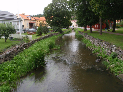
Above Left: Scandinavian Crow, Black and Dark Gray - They ALL look like this in Sweden.

Above Right: Cobble Stones, well done and in an old shell design/layout except for the rain drainage. BTW, the rain drain is often the smoother ride choice for cyclists.

Near the older center of Söderköping.

Above: Near the older center of Söderköping, a river runs through it. An old style Swedish Telephone Booth. A couple of cyclists just rolled in on panniers and stopped to reconnoiter, the (city) Stadt Hotel is just beyond their heads to the right.

Staden Regeringsbyggnaden. Staden Regeringsbyggnaden.

Above: Rear and Front of the City Government Building (Rathaus/Staden Regeringsbyggnaden).
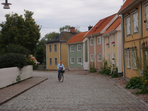

Old Red Brick Church (Kyrkan).

Above: Old Red Brick Church (Kyrkan). There are some older, Pre-Latinized Swedish Remembrance Markers around the church grounds, see below.

Bell Tower location other than on a church steeple. Remembrance Markers with Celtic Symbols and Viking Runes.

Above Left: It is customary for older Swedish [Christian] Churches to have a separate Bell Tower location other than on a church steeple. In many cases, we will learn later, the Bell Tower is positioned on a nearby hill top.

Above Right: There are Remembrance Markers with Celtic Symbol styling written in Viking Runes - All of the Markers seem to be attributes to relatives, rather than being actual grave stones.

His Hiness. Don't even think about parking here.

Above Left: Dream Big!

Above Right: I was surprised to see this sign in an alley way, in English: 'Don't think about parking here'.

Terry rides a Penny Farthing Sculpture. Varm Choklad.

Above Left: Terry rides a Penny Farthing Sculpture.

Above Right: Varm Choklad.


Hotel Brunn Dinner

Brunn Hotel Dining Room. Desert.

Above Left: Our Dining Room.

Above Right: Desert; We ate Dinner without thinking about taking a picture, sorry.


Previous Day  Top  Next Day